Sold For $20,133
*Includes Buyers Premium
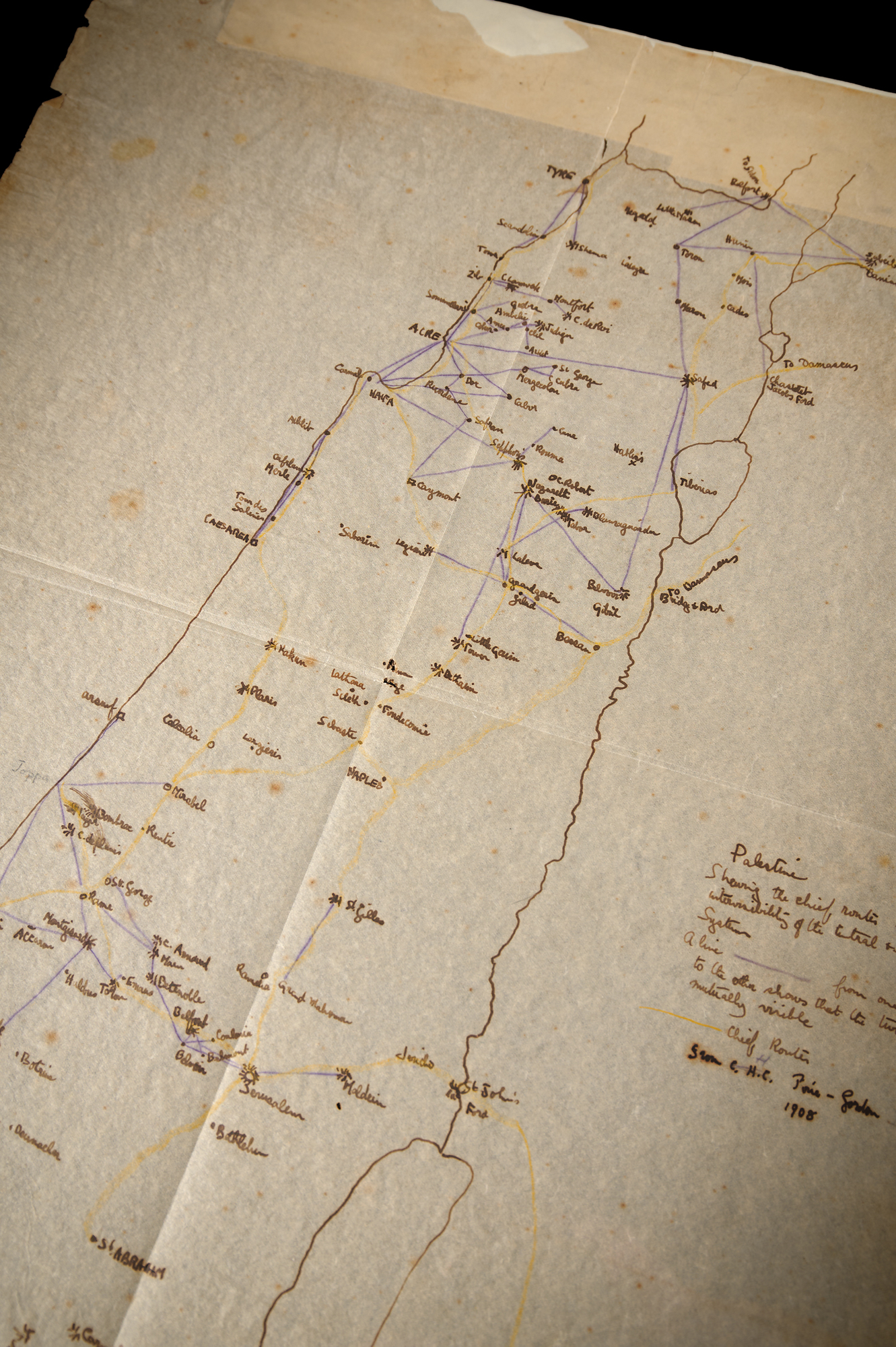
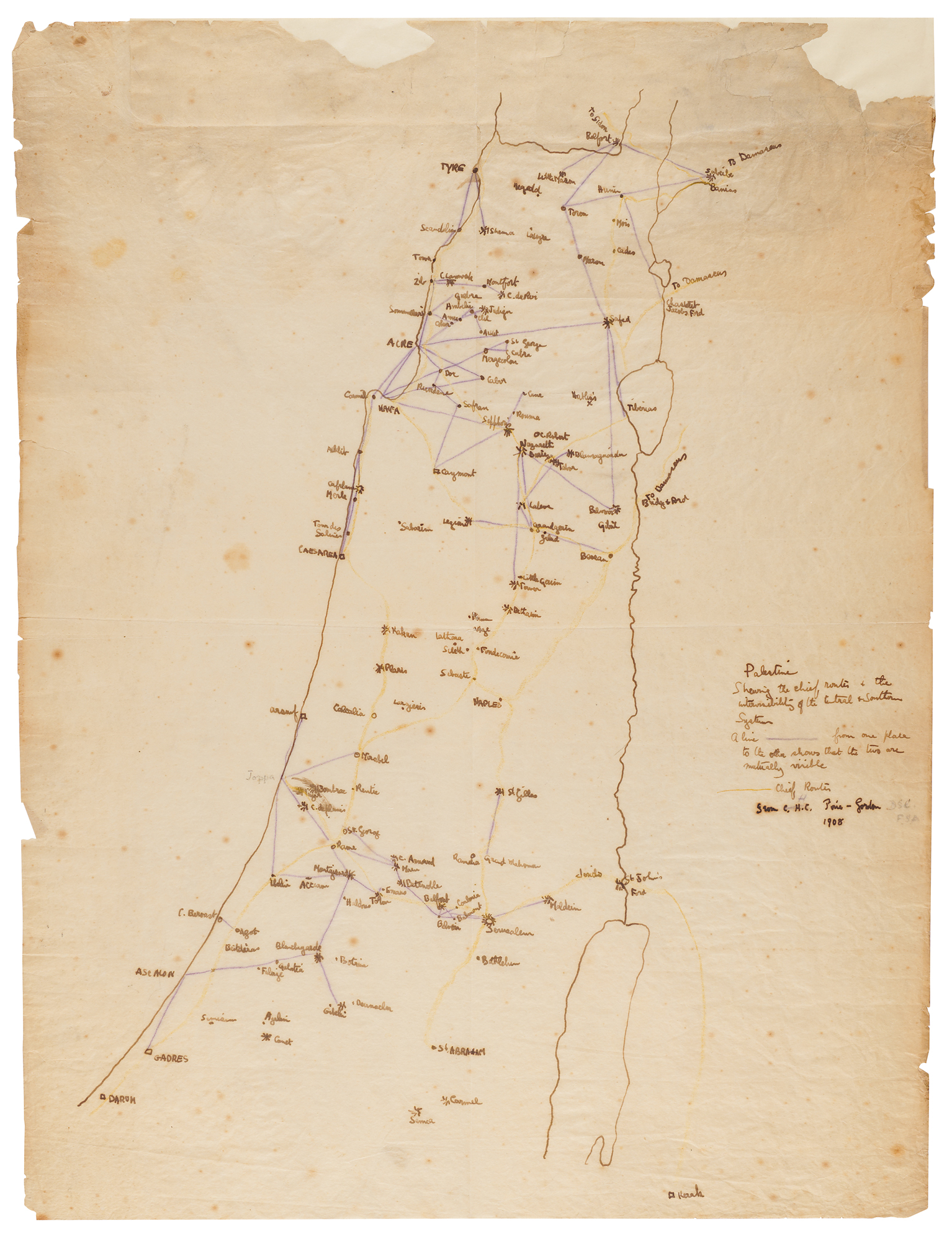
British archaeologist, soldier, adventurer, and writer (1888-1935) immortalized in the epic 1962 screen biography Lawrence of Arabia. He attained international renown for his role as British liaison in the Arab Revolt of 1916-1918, which he recounted in his best-selling memoir Seven Pillars of Wisdom. Hand-drawn map of Palestine accomplished by T. E. Lawrence, one onionskin page, 14.75 x 19.75, traced from a map made by H. Pirie-Gordon in 1908 and reproduced, after redrawing, as a large folding map in the first edition of Crusader Castles (1936), Lawrence's influential study of 12th-century Crusader castles and their relation to Western military architecture. Lawrence captions the map in the right margin: "Palestine, Shewing the chief routes & the intervisibility of the Central & Southern System. A line [purple] from one place to the other shows that the two are mutually visible. [Yellow line] Chief Routes. From C.H.C. Pirie-Gordon, 1908." Lawrence extensively annotates the map, covering it with the names of towns and castles, further annotating the routes and sight lines in yellow and purple pencil. In very good to fine condition, with intersecting folds, scattered light foxing, and some small losses and edge separations, with reinforcement backing strip at the top edge.
This map traces its origin to H. Pirie-Gordon—traveler, scholar, journalist, and intimate of the enigmatic Baron Corvo—who drafted the original during an 1908 horseback journey through Syria and Palestine. Lawrence encountered Pirie-Gordon in London in May 1909, at a pivotal moment: the young Oxford undergraduate was actively preparing for his own Syrian expedition, undertaken on foot and alone that summer, to survey Crusader fortifications for his BA thesis. For that demanding solo trek, Lawrence carried with him Pirie-Gordon's annotated maps as his guide through the region.
Returning to Oxford in the autumn of 1909, Lawrence completed the writing of his thesis over the winter months—possibly the period during which these careful tracings were made. The thesis earned him his degree and secured a traveling fellowship that led directly to his celebrated archaeological work at Carchemish. It was first published in 1936, expanded with letters home, under the title Crusader Castles; for that edition, the map offered here was redrawn for publication.
Pirie-Gordon himself recounts his meeting with Lawrence and the loan of his maps in a contribution to the landmark tribute volume T. E. Lawrence by His Friends (pp. 73–75).

This item is Pre-Certified by PSA/DNA
Buy a third-party letter of authenticity for
$50.00
*This item has been pre-certified by a trusted third-party authentication service, and by placing a bid on this item, you agree to accept the opinion of this authentication service. If you wish to have an opinion rendered by a different authenticator of your choosing, you must do so prior to your placing of any bid. RR Auction is not responsible for differing opinions submitted 30 days after the date of the sale.
Third-party authentication service applies only to signatures and handwriting, and does not cover the addition of sketches, artwork, musical quotations, etc.