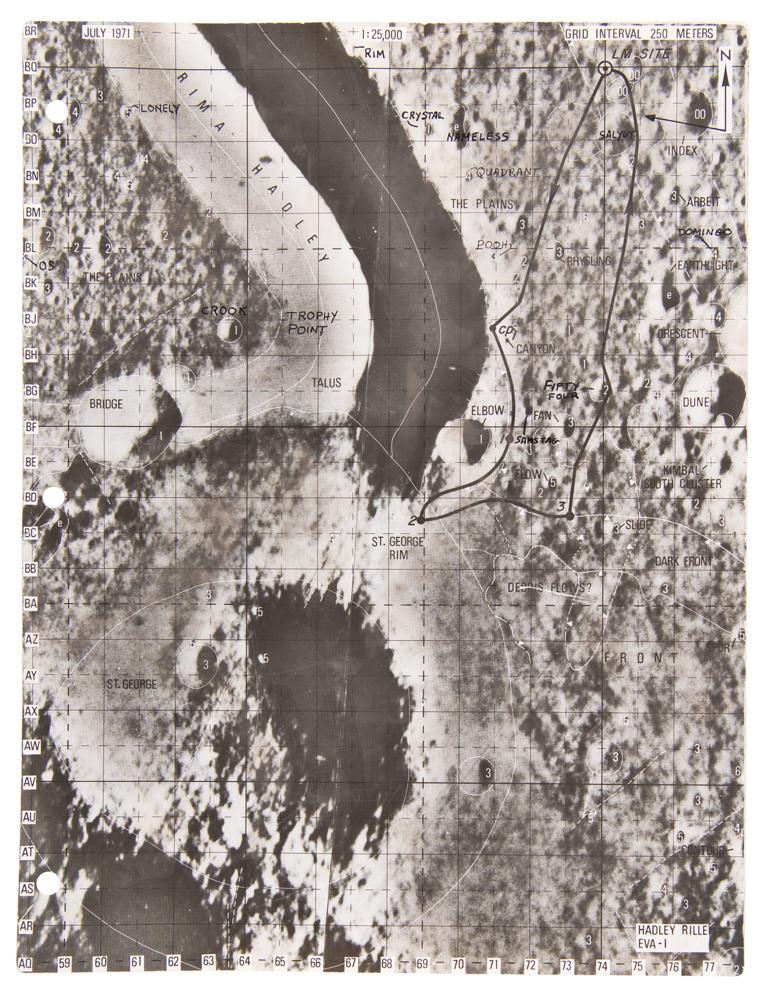
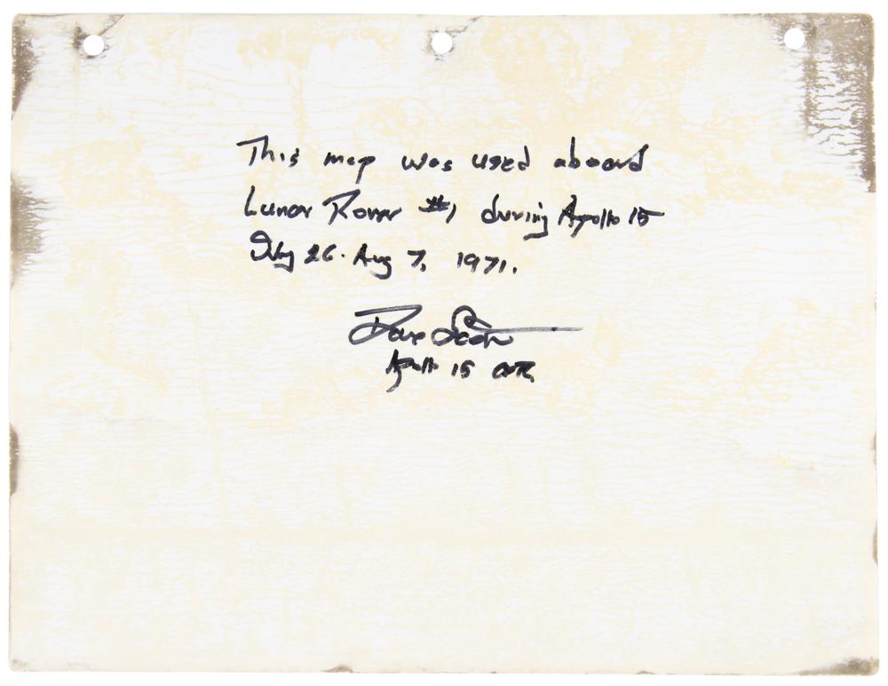

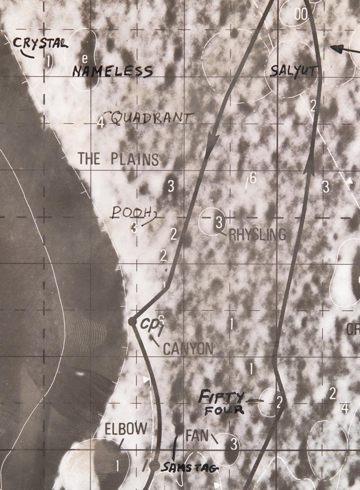
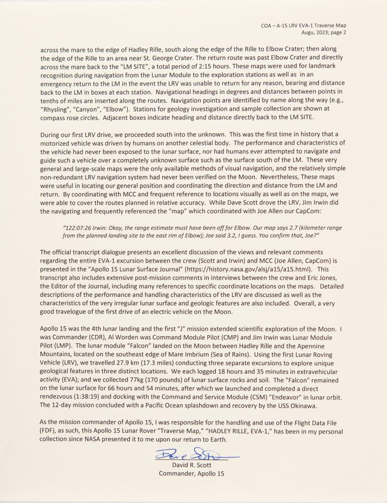
Remarkable lunar map used on the surface of the moon during the first EVA of Apollo 15—marking the debut of the Lunar Roving Vehicle (LRV)—labeled “Hadley Rille, EVA-I,” one page, 8 x 10.5, signed and flight-certified on the reverse in black felt tip, “This map was used aboard Lunar Rover #1 during Apollo 15, July 26-Aug 7, 1971. Dave Scott, Apollo 15 CDR.” The map traces the course of the first Apollo 15 EVA from the "LM Site" along the Rima Hadley, past Elbow Crater, to the rim of St. George Crater and back—a path covering about 9 km, which took about six and a half hours to complete. Major lunar geological features are indicated, with many of the craters identified by name. The map was clipped to the LRV accessory staff during EVA-1 so as to be readily available for navigational purposes, exposing it to lunar dust and the vacuum of space. In fine condition.
Accompanied by a detailed signed letter of provenance from Dave Scott, in part: "I hereby certify that the Apollo 15 Lunar Rover 'Traverse Map' labeled: 'HADLEY RILLE, EVA-1, JULY 1971' included with this letter was carried aboard Lunar Roving Vehicle #1 (LRV-1) while exploring the surface of the Moon during for three days at the Hadley Apennine site during Apollo 15?This map was extracted from the Apollo 15 'LM Lunar Surface Maps' book?These maps contain traces of lunar dust and were exposed to the temperature extremes, radiation, and Solar Wind on the surface of the Moon?These maps were used for landmark recognition during navigation from the Lunar Module to the exploration stations as well as in an emergency return to the LM in the event the LRV was unable to return for any reason?During our first LRV drive, we proceeded south into the unknown. This was the first time in history that a motorized vehicle was driven by humans on another celestial body. The performance and characteristics of the vehicle had never been exposed to the lunar surface, nor had humans ever attempted to navigate and guide such a vehicle over a completely unknown surface such as the surface south of the LM. These very general and large-scale maps were the only available methods of visual navigation, and the relatively simple non-redundant LRV navigation system had never been verified on the Moon. Nevertheless, These maps were useful in locating our general position and coordinating the direction and distance from the LM and return. By coordinating with MCC and frequent reference to locations visually as well as on the maps, we were able to cover the routes planned in relative accuracy."

This item is Pre-Certified by STEVE ZARELLI
Buy a third-party letter of authenticity for
(inquire for price)
*This item has been pre-certified by a trusted third-party authentication service, and by placing a bid on this item, you agree to accept the opinion of this authentication service. If you wish to have an opinion rendered by a different authenticator of your choosing, you must do so prior to your placing of any bid. RR Auction is not responsible for differing opinions submitted 30 days after the date of the sale.
Third-party authentication service applies only to signatures and handwriting, and does not cover the addition of sketches, artwork, musical quotations, etc.