
Sold For $4,441
*Includes Buyers Premium
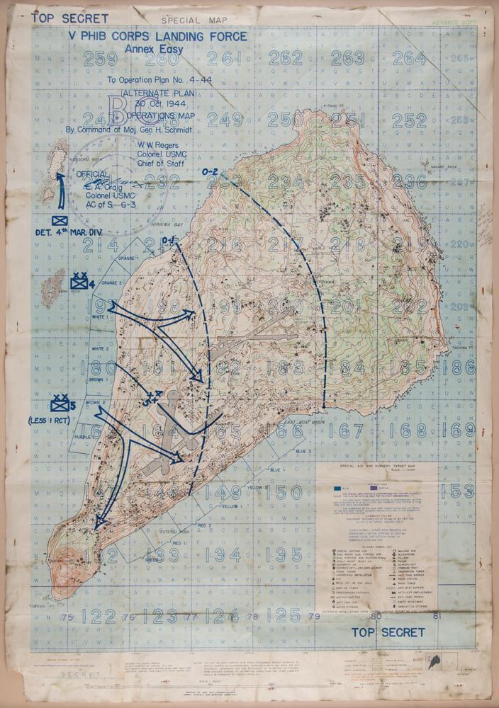
Scarce World War II-dated 'Special Map' of Iwo Jima, headed "Top Secret," 28 x 40, prepared for CINPAC-CINCPOA [Commander in Chief, Pacific Fleet - Commander in Chief, Pacific Ocean Areas] by 64th Engr. Top. Bn. USAFICPA in October 1944. The map provides an overview of an alternate invasion route for the V Amphibious Corps, commanded by General Harry Schmidt, and is titled: "V Phib Corps Landing Force, Annex Easy, To Operation Plan No. 4-44, (Alternate Plan) 30 Oct. 1944, Operations Map." Interestingly, this map provides for a landing on the west coast; ultimately, the Marines would land on the southeastern side of the island in February 1945. At a scale of 1:10,000, this "Special Air and Gunnery Target Map" identifies dozens of Japanese defense sites, using symbols described in a "Defense Symbol Key," including coastal defense guns, anti-aircraft guns, foxholes, anti-tank guns, machine guns, water storage, blockhouses, radar, searchlights, observation towers, anti-boat barriers, radio towers, ammunition storage, and other structures, obstacles, and military installations.
Further, the map notes that it is "printed on high wet strength paper (highly durable and moisture resistant)"—ideal for use in the field—and has a cautionary warning: "This map has been compiled from aerial photographs without advantage of ground control or reconnaissance; therefore azimuth and scale are not accurately determined." Mounted and framed to an overall size of 33 x 44.5. In very good to fine condition, with scattered staining, primarily to the borders.
This map demonstrates the intensive effort that went into planning the American invasion of Iwo Jima, which would begin three months later on February 19, 1945. In spite of some knowledge of the island's heavy fortifications—some 30 distinct symbols representing the Japanese Army's positions are used here—the density and capability of the Japanese defenses were still severely underestimated, resulting in some of the fiercest and bloodiest fighting of the Pacific War. Ultimately, the V Amphibious Corps—comprised of the 3rd, 4th and 5th Marine Divisions—succeeded in their mission, taking control of the island on March 26th.