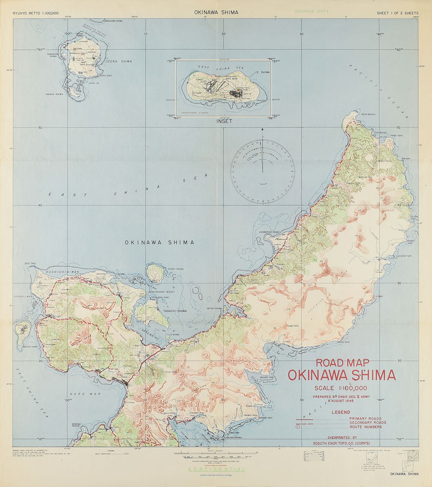
A remarkable map entitled "Okinawa Shima" showing the northern part of Okinawa Island, prepared by US Tenth Army Engineers on August 8, 1945, just two days after Hiroshima and one day before Nagasaki. Marked "Confidential: This classification will be changed to restricted in combat area" at bottom. Pencil inscribed "Northern part" twice verso. Lightly folded into six even sections, measuring approximately 20 x 22.5 unfolded. In fine condition.
The Battle of Okinawa (code name Operation Iceberg) took place on Okinawa Island between April 1-June 22, 1945. One of the Ryukyu Islands extending southwest of the Japanese mainland, Okinawa was of paramount strategic importance. Allied forces needed it to launch Operation Downfall, the large-scale on-the-ground invasion of Japan anticipated to begin in November 1945. Okinawa would have been the main staging ground for an invasion projected to require 700,000-1,700,000 troops and result in an estimated 400-800,000 American fatalities. Researchers believed the invasion would take at least two years.
After the United States dropped atomic bombs on Hiroshima on August 6 and Nagasaki on August 9, Japan announced its intention to surrender. Yet the cancellation of the invasion did not negate the island's overall importance to American interests: there are US Army installations on Okinawa Island to this day.
Before this outcome was known, though, Allied forces, the bulk of which were US Army and Marines, faced off against the Imperial Japanese Army and conscripted indigenous Okinawan civilians that spring. The Allies launched a multi-pronged amphibious assault of Okinawa and surrounding islands. Although the Allies significantly outnumbered defenders, the Japanese brooked their efforts with kamikaze and other extreme defense tactics. Approximately 250,000 died from war, starvation, illness, and mass suicide in what would be the bloodiest battle in the Pacific Theater.
This map was originally drafted before the Battle of Okinawa, in January 1945, and then updated after the battle. The map shows primary and secondary roadways intersecting the island. Limited topographical features on the map show the heavily overgrown and mountainous terrain. A Japanese-English glossary of helpful topographical terms underscores the nature of the foreign invasion.
The conquest of northern Okinawa was slated for Phase II of the island invasion, but it was undertaken ahead of schedule because Allied forces storming beaches further to the southwest on April 1, 1945 encountered such little resistance. By April 7, Allied forces had sealed off the Motobu Peninsula, and less than a week later US Marines had cleared Hedo-Misaki, the northernmost post of Okinawa, shown in the upper right quadrant of this map.
The map also shows an inset of Iejima, a smaller island located to the west of Okinawa. It was here that American war correspondent Ernie Pyle was killed while canvassing terrain in a jeep on April 18, 1945. He was buried in his battle helmet between two other servicemen.
We use cookies on this site to improve your experience. By using this site, you accept our use of cookies. To learn more, please see our Privacy Policy.