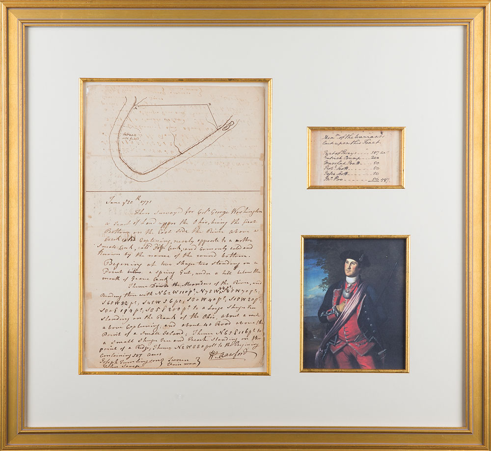
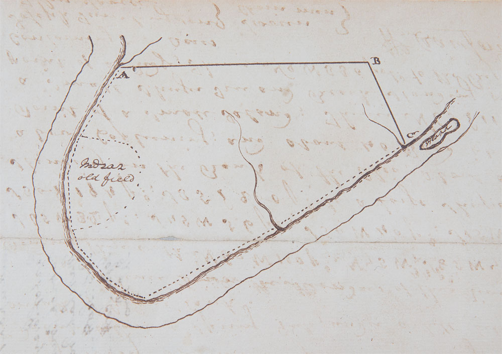
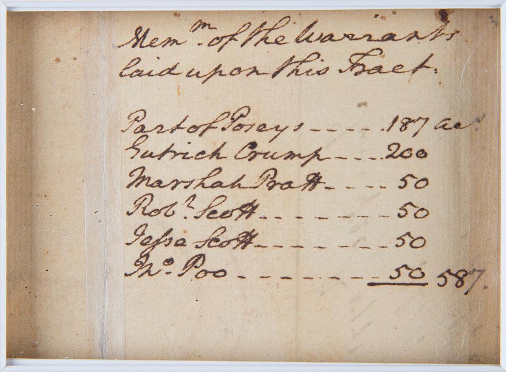
Remarkable hand-drawn survey map by George Washington, with an eight-line handwritten endorsement on the reverse, one page, 8 x 12.75, June 20, 1771. At the top of the page, Washington draws a survey map of land comprising 587 acres in the Ohio Valley, annotating two geographical landmarks: "Indian, old field" and "Island." On the reverse, Washington writes: "Mem'm of the Warrants laid upon this Tract. Part of Posey's—187 ac's, Gutrick Crump—200, Marshah Pratt—50, Rob't Scott—50, Jesse Scott—50, Jno. Poe—50: 587."
Below Washington's sketch on the front is a description written by fellow surveyor Col. William Crawford, in part: "June 20th 1771, Then surveyed for Colo. George Washington a Tract of Land upon the Ohio, being the first Bottom of the East side of the River, above a creek called Capteniny, nearly opposite to another small creek, call'd Pipe Creek." He goes on to describe land and provide coordinates. Attractively corner-mounted, matted, and framed with a portrait and a color copy of Washington's writing on the reverse to an overall size of 22.25 x 20.5. In fine condition, with a reinforced fold next to Washington's handwriting.
This phenomenal document boasts historical importance associated with Washington’s 1770 exploration of the Ohio River Valley. In the diary kept from his canoe and campsites along the Ohio River, Washington recorded his observations of the area, including notes on the Native American Indian populations he encountered. Washington details this specific area on October 24-25, 1770, noting: ‘We left our encampment before sunrise, and about six miles below it we came to the mouth of a small creek, coming in from the eastward, called by the Indians Split-Island Creek, from its running in against an island On this creek there is the appearance of good land.’ He goes on to note ‘Pipe Creek, so called by the Indians from a stone, which is found here, out of which they make pipes,’ below which is ‘a pretty large creek on the west side, called by Nicholson, Fox-Grape-Vine, by others Captema Creek, one which, eight miles up, is the town called the Grape-Vine Town; and at the mouth of it is the place where it was said the trader was killed.’ He later learns that the trader was not killed by Indians, but drowned in the river.
Washington, one of Virginia’s most prominent landowners, ultimately acquired the plot of land sketched here, holding it for much of his life. In advertising his Ohio lands for sale on February 1, 1796, he described the plot as ‘called Round Bottom…about 15 miles below Wheeling, a little above Captenon, and opposite to Pipe-Creek; bounded by the river in a circular form for 2 miles and 120 poles containing 587 acres.’ The autograph of Col. William Crawford is also especially notable: a comrade-in-arms and fellow surveyor, he became acquainted with Washington in 1749 and served in Washington’s Virginia Regiment prior to the Revolution. He commanded troops in the Continental Army during the Revolutionary War, and was ultimately tortured and burned at the stake by American Indians in retaliation for the Gnadenhutten massacre, a notorious 1782 incident in which 96 peaceful Christian Lenape Indians were massacred. An absolutely incredible piece of tremendous historical significance.

This item is Pre-Certified by PSA/DNA
Buy a third-party letter of authenticity for
$300.00
*This item has been pre-certified by a trusted third-party authentication service, and by placing a bid on this item, you agree to accept the opinion of this authentication service. If you wish to have an opinion rendered by a different authenticator of your choosing, you must do so prior to your placing of any bid. RR Auction is not responsible for differing opinions submitted 30 days after the date of the sale.
We use cookies on this site to improve your experience. By using this site, you accept our use of cookies. To learn more, please see our Privacy Policy.