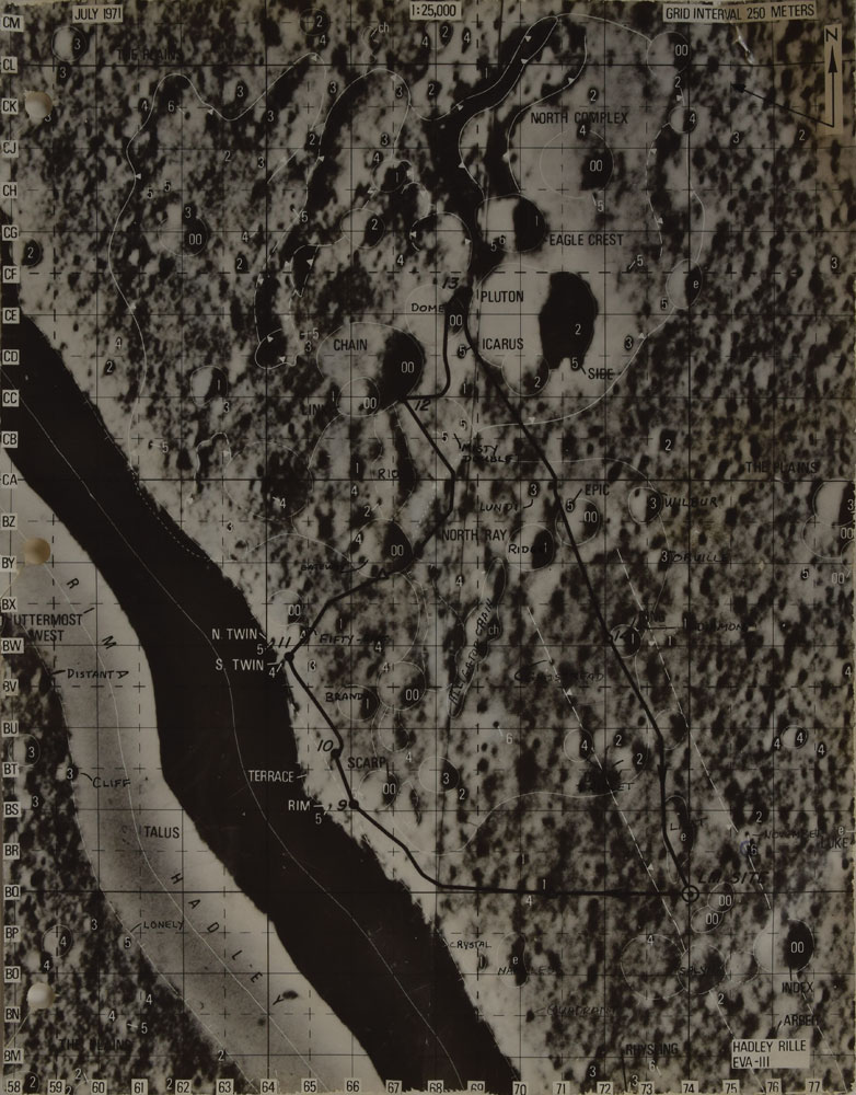
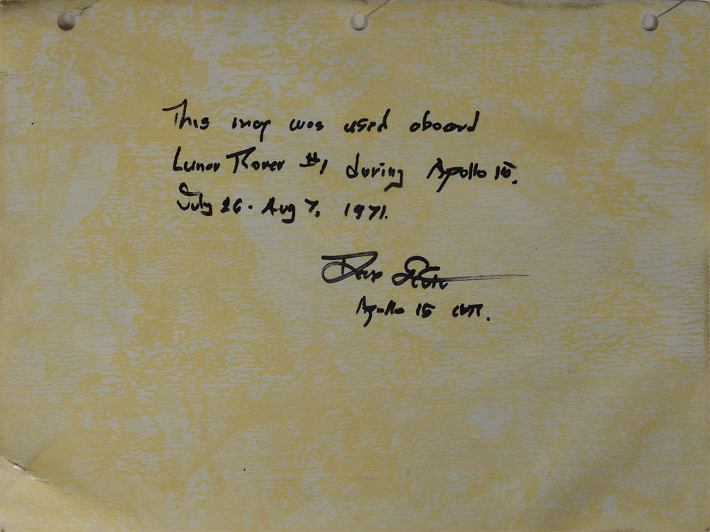
Remarkable lunar map used on the surface of the moon, labeled “Hadley Rille, EVA-III,” one page, 8 x 10.5, signed and certified on the reverse in black felt tip, “This map was used aboard Lunar Rover #1 during Apollo 15, July 26-Aug 7, 1971. Dave Scott, Apollo 15 CDR.” The map bears a few of Scott’s handwritten notations identifying various areas and geological features of the moon’s surface, including “Dome,” “Fifty-Five,” “Brandy,” “Gateway,” “Misty Doublet,” “Distant,” “Cliff,” “Lonely,” and most interestingly the craters named after the Wright Brothers, “Wilbur” and “Orville.” In fine condition, with light toning to adhesive remnants on reverse and expected wear from mission use.
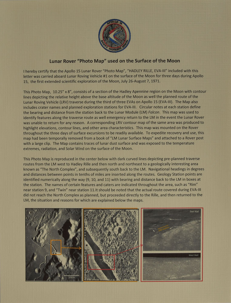
Accompanied by a detailed signed letter of provenance from Dave Scott, in part: “I hereby certify that the Apollo 15 Lunar Rover ‘Photo Map,’ ‘Hadley-Rille, EVA-III,’ included with this letter was carried aboard Lunar Roving Vehicle #1 on the surface of the Moon for three days during Apollo 15, the first extended scientific exploration of the Moon…This maps was used to identify features along the traverse route as well as emergency return to the LM in the event the Lunar Rover was unable to return for any reason. A corresponding LRV contour map of the same area was produced to highlight elevations, contour lines, and other area characteristics. This map was mounted on the Rover throughout the three days of surface excursions to be readily available. To expedite recovery and use, this map had been temporally removed from a book of ‘LM Lunar Surface Maps’ and attached to a Rover post with a large clip. The map contains traces of lunar dust surface and was exposed to the temperature extremes, radiation and Solar Wind on the surface of the Moon.” This photo map and the corresponding contour map—offered as lot 8328—cover exactly the same area, providing a rare opportunity to own a matching pair.
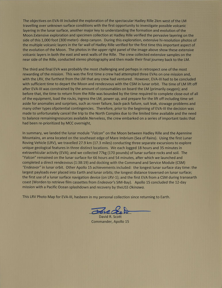
This map represents the intended path of the Lunar Rover on the last EVA of the Apollo 15, the first mission to use the vehicle, and has the LM site and EVA Stations 9-14 labeled. Their route was shortened in order to meet the liftoff timeline and thus they take the exact path depicted on this map. During the third EVA Dave Scott and Jim Irwin collected over one hundred samples from the surface and performed extensive photography tasks. Once they returned to the LM at the conclusion of EVA-III, Commander Scott performed what is probably the most famous experiment to ever be conducted on the moon when he simultaneously dropped a hammer and a feather to the surface. They hit the ground at the same time, proving Galileo’s centuries-old theory of falling objects in a vacuum. As a map actually used by Commander Scott during the final leg of his lunar surface operations, this is a quintessential relic of the Apollo 15 mission.

This item is Pre-Certified by STEVE ZARELLI
Buy a third-party letter of authenticity for
$25.00
*This item has been pre-certified by a trusted third-party authentication service, and by placing a bid on this item, you agree to accept the opinion of this authentication service. If you wish to have an opinion rendered by a different authenticator of your choosing, you must do so prior to your placing of any bid. RR Auction is not responsible for differing opinions submitted 30 days after the date of the sale.
We use cookies on this site to improve your experience. By using this site, you accept our use of cookies. To learn more, please see our Privacy Policy.