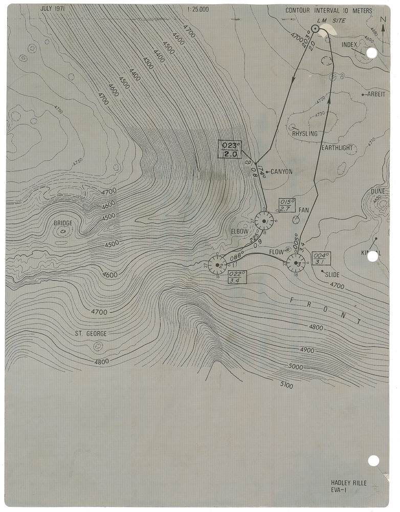
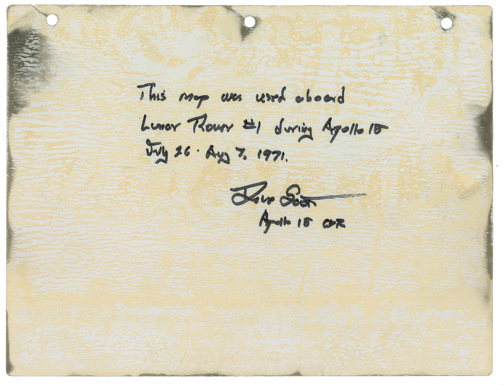
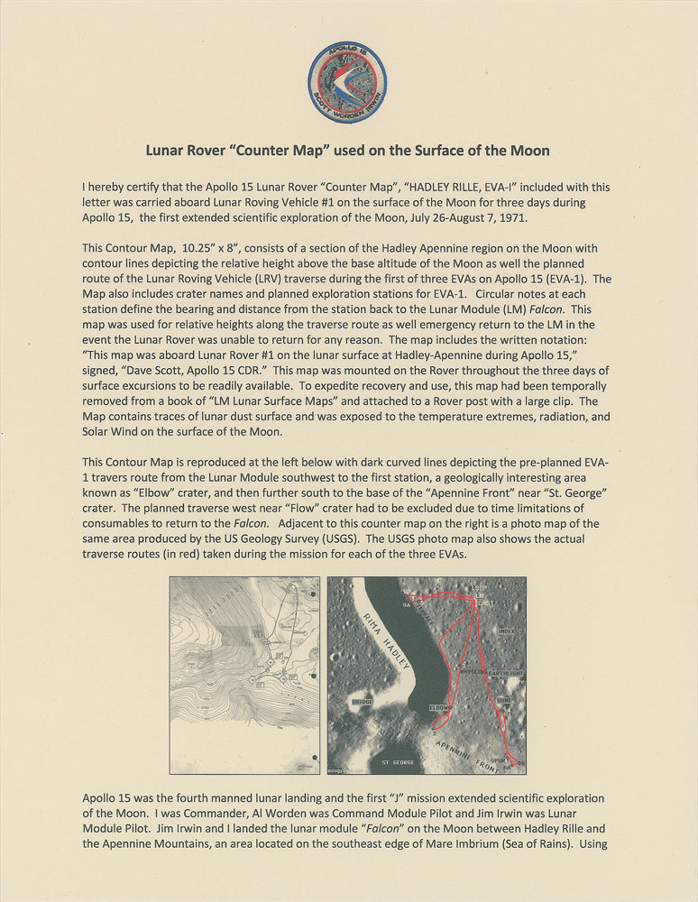
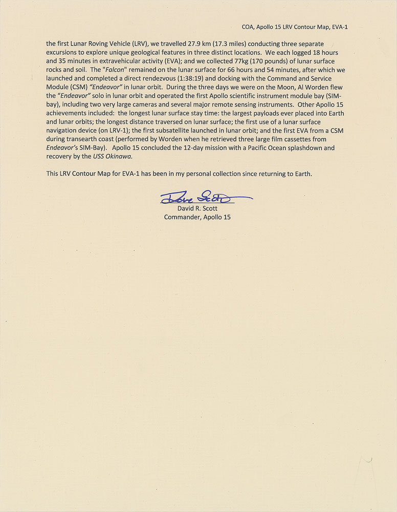
Incredible flown Apollo 15 topographical map carried on board Apollo 15, measuring 10.25 x 8, dated July 1971, labeled in the lower right, “Hadley Rille, EVA–1,” and in the upper right, “Contour interval 10 Meters.” Used as a navigation guide during the first EVA conducted by a lunar rover on the surface of the moon, the map shows the metric depth of the rille and the height of Mount Hadley Delta, offering a detailed exploration route with various location markers, “Bridge,” “St. George,” “Slide,” “Flow,” “Canyon,” “Fan,” “Earthlight,” and “Dune.” Smudging on the sides of the map indicate interaction with the lunar surface. Signed and flight-certified on the reverse in black felt tip by Dave Scott, “This map was used aboard Lunar Rover #1 during Apollo 15, July 26–Aug. 7, 1971. Dave Scott, Apollo 15 CDR.” In fine condition, with expected wear from use. Accompanied by a signed certificate of authenticity from Apollo 15 Commander Scott, in part: “I hereby certify that the Apollo 15 Lunar Rover ‘Contour Map’…was carried aboard Lunar Roving Vehicle #1 on the surface of the Moon for three days during Apollo 15…This Contour Map…consists of a section of the Hadley Apennine region on the Moon with contour lines depicting the relative height above the base altitude of the Moon as well the planned route of the Lunar Roving Vehicle traverse during the first of three EVAs on Apollo 15…The Map also includes crate names and planned exploration stations for EVA–1. Circular notes at each station define the bearing and distance from the station back to the Lunar Module Falcon. This map was used for relative heights along the traverse route as well as emergency return to the LM in the event the Lunar Rover was unable to return…This map was mounted on the Rover throughout the three days of surface excursions to be readily available…The Map contains traces of lunar dust surface and was exposed to the temperatures extremes, radiation, and Solar Wind on the surface of the Moon…This LRV Contour Map for EVA–1 has been in my personal collection since returning to earth.” Crucial to the mission’s extensive lunar exploration, this Apollo 15 contour map exists as a true space relic used directly on the surface of the moon. Pre-certified Zarelli Space Authentication.

This item is Pre-Certified by STEVE ZARELLI
Buy a third-party letter of authenticity for
(inquire for price)
*This item has been pre-certified by a trusted third-party authentication service, and by placing a bid on this item, you agree to accept the opinion of this authentication service. If you wish to have an opinion rendered by a different authenticator of your choosing, you must do so prior to your placing of any bid. RR Auction is not responsible for differing opinions submitted 30 days after the date of the sale.
We use cookies on this site to improve your experience. By using this site, you accept our use of cookies. To learn more, please see our Privacy Policy.